The new Municipal Action Plan for Flood Risk (PAMIN) warns of 23 critical flood zones in Torrevieja. This document, commissioned by the City Council to comply with risk prevention legislation, is prepared with the aim of achieving “maximum protection” for people, property and the environment, that may be affected by flooding in the city.
In addition to identifying the areas of greatest risk, including public infrastructure, it establishes a hierarchical structure of the municipality’s means and resources, both public and private, that allows it to deal with risk or serious emergency situations.
The company that has been awarded the work, Strato Sismic, has defined vulnerable areas based on the risk analysis and its levels in the different areas of Torrevieja, using all types of technical tools. and the mapping of the Patricova and the CHS, but also with work on the ground.
Among the 23 risk areas identified in the document, special mention is made of two located on the east shore of the Torrevieja lagoon: Torreta Florida, and El Salado and Torreta III.
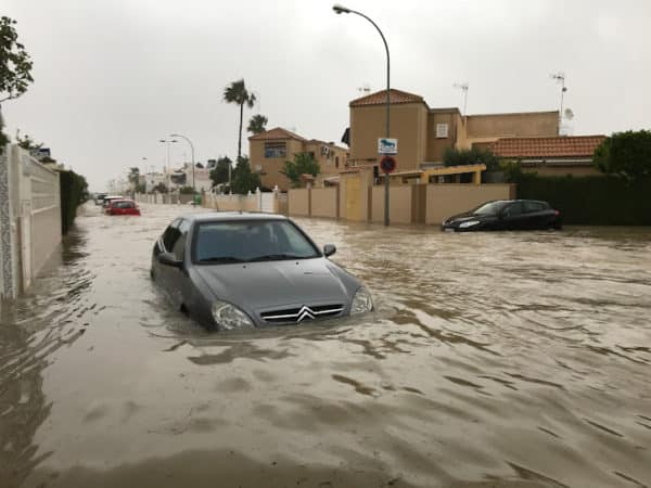
The document states that these are areas located below sea level where significant accumulations of water occur, with inadequate drainage, and where water remains stagnant for long periods of time, causing logistical and health problems. The identification of the flood risk in this area in the regional risk plan was first made in 2015, almost four decades after the residential areas were built.
Most of the rest of the 21 critical points are located in geomorphological danger zones and are associated with the alteration or integration into the urban fabric of boulevards, ravines, alluvial fans, spills, or flat-bottomed valleys that, in the event of episodes of very localised rain or of high hourly intensity, can be activated suddenly or lead to flooding of depressed sectors with repercussions on mobility and road traffic.
Among these critical areas, it identifies la calle Rambla Juan Mateo street – where the work to duplicate the current stormwater basin is about to begin; calle Navegantes and adjacent streets; la cala del Palangre and la Avenida de las Habaneras, la Avenida Roentgen, Alfredo Nobel (222) and la Avenida Alfredo Nobel Avenue in la cala de la Zorra.
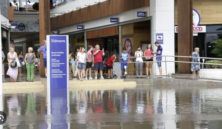
The entire area around the Casa Grande industrial estate and the avenues of the Cortes Valencianas, Rosa Mazón and Delfina Viudes also stand out; the Doña Inés urbanization, including the large stores of Carrefour, Habaneras and Ozone, the CV-95; the Torreta Florida urbanization; la calle Mar Menor and the Torrevieja University Hospital car park.
Many of these areas, to a greater or lesser extent, are where, in recent years, the City Council with the water cycle management company has acted to improve the drainage of rainwater with a network that already has 29 kilometres of collectors.