More than 200 tremors are recorded across Alicante province each year. Most are too small to feel, but the Vega Baja lies in the most seismically hazardous part of the Valencian Community.
Beneath Alicante, the ground is almost never completely still. The Valencian Community Seismic Network, SISCOVA, records more than 200 earthquakes in the province each year, although the vast majority are so small that residents never feel them.
The figure is striking, particularly after a noticeable tremor. It does not mean that hundreds of dangerous earthquakes are occurring. It does show, however, that Alicante sits in an active seismic region with a history of far more powerful events.
The movement begins deep below the surface. According to geological outreach group GeoAlicante, the Nubian tectonic plate beneath Africa and the Eurasian plate are moving towards one another at approximately five millimetres a year. That slow, relentless pressure helps explain the earthquakes detected across the province.
Nowhere in the Valencian Community is the seismic hazard greater than in the Vega Baja. The area is crossed by a system of faults associated with some of the strongest earthquakes in Alicante’s recorded history.
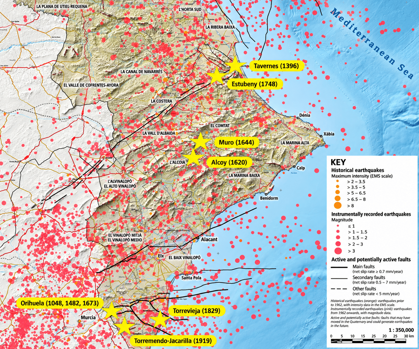
The most devastating reminder is the Torrevieja earthquake of 1829, estimated to have reached magnitude 6.5. Its place in local history remains a warning of what the ground beneath the southern part of the province is capable of producing.
Another significant earthquake struck the Jacarilla–Torremendo area in 1919. At magnitude 5.5, it is identified in SISCOVA records as the strongest earthquake of the region’s instrumental period.
A key part of this picture is the Lower Segura Fault system. It extends through southern Alicante and continues eastwards beneath the Mediterranean Sea. Its effects are reflected in geological folds associated with the Hurchillo, Benejúzar and Guardamar ranges.
Together, the fault system and the historical record explain why the Bajo Segura stands out on maps of seismic hazard. The risk does not end at the southern edge of the province, however. The l’Alcoià area in northern Alicante has also experienced damaging earthquakes, including significant events in 1620 and 1644.
Could another major earthquake strike? History shows that it is possible. What scientists cannot determine is the precise day, location or magnitude of a future event. Monitoring can reveal where tremors occur and improve understanding of active faults, but it cannot provide an exact prediction.
That uncertainty makes public awareness valuable. Knowing how earthquakes happen, recognising the risk in a particular area and understanding what to do during a strong tremor are more useful than treating every small, recorded quake as a warning of an imminent disaster.
Those questions were explored at the University of Alicante last Friday, during European Researchers’ Night. The Department of Earth and Environmental Sciences demonstrated how a seismograph detects movement, they explained how seismic waves travel and they offered an interactive look at how faults work.
Most of Alicante’s 200-plus annual tremors will continue to pass unnoticed. But the province’s seismic past, particularly in the Vega Baja, is a reminder that rare, powerful earthquakes are part of its history—and that preparation matters precisely because nobody knows when the next one will come.
Historical earthquakes in Alicante. / GeoAlicante