The Institut Cartogràfic Valencià (ICV), a dependent body of the Ministry of Environment, Infrastructure and Territory, has concluded the so-called ‘Flight 2024’ in which 6,407 digital aerial photographs of 22 centimetre resolution have been taken of the whole of the Valencian territory and which, right now, are being processed for publication in the photo library, which can be accessed at the web address of the geophoto library of the Institut Cartogràfic Valencian. The ICV carries out a flight every year whose consultation is universal and free on the Internet.
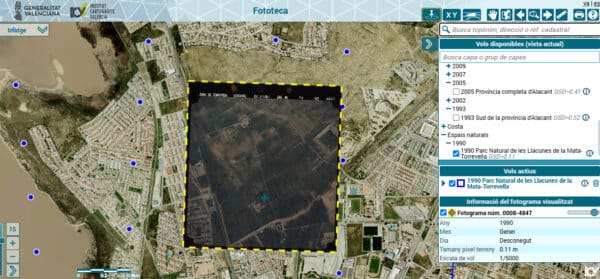
The photo library of the Institut Cartogràfic Valencià is one of the integral applications of the digital card library and, therefore, another element of the Valencian Cartographic System. In the photo library, access is given to the visualisation, consultation, printing and certification of more than 250,000 historical frames obtained in more than 120 different photogrammetric flights carried out over time. In fact, the oldest flight that is preserved is the one made in 1929 by the aviator and soldier Julio Ruiz de Alda over the south of the province of Alicante and which consists of 3,522 photographs.
Councilor Vicente Martínez Mus has highlighted that the ICV’s photo library “gathers the largest historical fund of geographical information of the Valencian Community which continues to grow thanks to the work of the professionals who have turned the Institute into a technical and scientific reference for first order that must be claimed”.
The councillor explained that the planes contracted by the Generalitat to make the flight each year are equipped with positioning instruments and inertial systems that make it possible to have the spatial position of each of the projection centres of the frames, which allows georeferencing quickly and accurately each image.
In addition to the photographs taken by the ICV, the photo library also has older flights from other administrations such as the cadastre or hydrographic confederations, the Government and even the United States Air Force.
In fact, in the photo library of the ICV you can consult the images taken by the so-called ‘American Flight, Series A’ which was carried out between 1945 and 1947 with Fairchild K-17B and Fairchild K-18 cameras and which it served the allies to plan the end of World War II.
Also preserved is the panchromatic photogrammetric flight made in the period between 1976 and 1978, commissioned by the Ministries of Agriculture, Public Works and Urbanism, Finance, Air and the Geographical and Cadastral Institute and the photogrammetric flight in RGB colour commissioned by the National Geographic Institute in 1999.
In this sense, Councilor Martínez Mus highlighted “the exponential growth in the use of the ICV’s photo library by the public”, since, during the year 2023, the ICV did through this tool certifies more than 6,000 frames and during the first six months of 2024 more than 78,000 views of historical frames have been facilitated and more than 5,000 certifications have been issued.
The website to view the galleries is, https://geofototeca.gva.es/visor_fototeca/ (it takes a little bit of getting used to and working out, but worth the effort if you are interested in local history)