The second phase of the La Zenia sustainable urban drainage project is taking shape again after having to be modified due to problems with the composition of the area’s subsoil, in addition to the water table, which has caused it to be paralysed for a year.
The Generalitat Valenciana has put on public display the authorisation for the discharge of rainwater into the sea from the sustainable urban drainage project in La Zenia. The initial project was awarded in mid-2022 for 1.5 million euro.
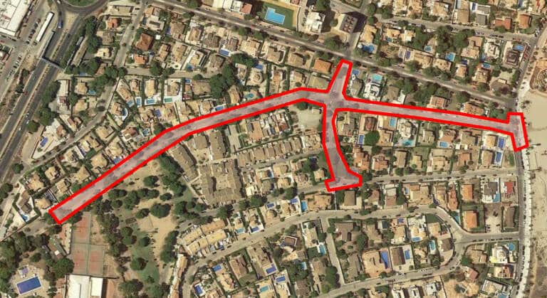
The scope of action included in the project has an area of about 6,300 square metres and covers almost the entire Avenida de las Palmeras, which is located between the junctions with the N-332 and Cala Bosque.
The action begins about 150m downstream of the aforementioned crossing, has a length of about 570m and a gentle longitudinal slope that varies between 1 and 2%. In addition, the project includes in its scope Calle del Carmen, in the section between Calle Colón and Avenida de la Playa and a section of Paseo del Mar.
During the tastings to carry out the project, several problems arose that have forced the initial project to be modified. In the first survey, a clayey-muddy terrain with the presence of algae up to 6 metres deep was detected in the area closest to the beach that would affect a section of the Avenida de las Palmeras collector. This is unstable terrain below the water table (1.15m deep) and remains present up to 6m depth of the survey.
In the second survey, a highly fractured calcareous crust was detected from 1.40m deep to 6m deep at which the survey reaches, which is expected to affect a section of the Avenida de las Palmeras collector. It is a very fractured rocky terrain below the water table (2.1m deep) and remains present up to the 6m depth of the survey. The permeability of this land is very high and the depletion of the groundwater is very complicated.
In the third, a very fractured rocky terrain was found from 2.5m deep to 5m deep to which the survey reaches, which is expected to affect a section of the Avenida de las Palmeras collector in the furthest section of the beach. It is a rocky terrain below the water table (3.2m deep) and remains present up to 5m deep, with clayey silt with nodules appearing again between 5 and 6m. The permeability of this land is very high and the depletion of the groundwater is very complicated.
The projected work contemplates the excavation of a trench suitable to house two caissons of 2×2 interior dimensions, placed end to end, with a trench excavation width of 5.20 m at its end. This width of the trench does not allow for carrying out the assembly and compaction work of the frame gables and sealing of joints, and above all the placement of shoring panels for the safety of the work in the trench, making it necessary to have a width of at least one metre on each side of the walls of the prefabricated modules.
The City Council and Hidraqua hope to be able to continue with works that are highly demanded by the residents of the area, who will also now be more aware of the type of land their properties are built on, due to the problem of flooding with each episode of rain that has continued for years.